People for the People
Overview
P4TP was a GIS community focused on educating and empowering community members to engage with civic issues. P4TP created geospatial solutions to re-center political issues back on the people—your friends, your family, your neighbors, and you—and elevating marginalized communities. Leading up to the 2020 U.S. presidential election, P4TP used GIS to re-imagine how we engage with politics and politicians by breaking down the complex system into digestible maps, apps, and stories that have lived on after the 2020 election. Together, P4TP weaved a story of the people, from local to national scales across the political landscape of the United States.
My Impact
- Achieved global visibility and recognition for the company.
- Led and managed a team of 150+ professionals.
- Directed the development and launch of 110 Esri products.
- Developed and communicated the visionary direction of the initiative.
- Led and collaborated with creative and design teams.
- Formulated strategy and vision for development teams.
- Took a leading role in research efforts, contributing to innovation and insights.
How It Works
During the 2020 election, our website played a pivotal role in providing community members and leaders with essential information on voting procedures and served as a platform for interaction with various information products we developed. It served as an inspirational resource, showcasing the potential for building community mapping organizations and multiple applications that catered to the needs of the community.
My contribution
Visionary and strategy Org structure Marketing strategy Acting CPO and CDO
The team
Esri Volunteers External Community Chief Scientist, Esri Head of Brand, Esri
Year
2020-21

Process
Creating the Team
Our first step was to recruit individuals and mobilize a complete organization. To generate interest, we utilized a combination of a video and survey to communicate our mission and capture the attention of potential participants. Subsequently, we organized kickoff sessions to address any inquiries and provide individuals with the opportunity to make an informed commitment.
The success of our endeavor was greatly influenced by our ability to effectively market the initial concept and captivate individuals with a compelling story. By sharing an engaging narrative, we were able to cultivate a sense of intrigue and inspire people to join us in our mission to make a difference.

Making It Personal
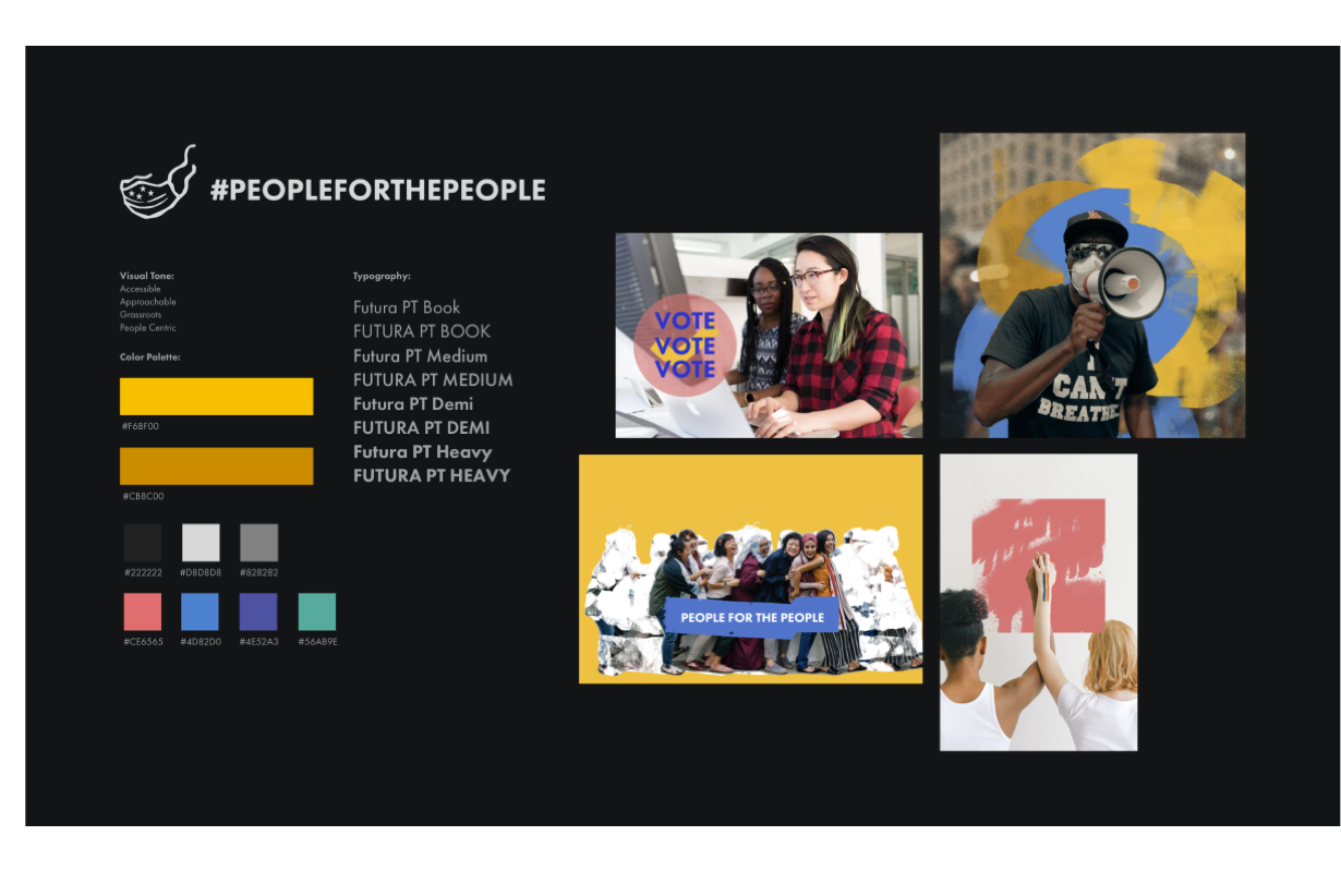
The primary objective of the website was to foster a sense of connection and engagement by highlighting real social issues and showcasing the experiences of authentic individuals. To achieve this goal, we designed the hero carousel to feature people from diverse backgrounds, accompanied by relatable statements that resonated with a wide range of visitors.
Drawing inspiration from successful grassroots activist efforts, we ensured that the brand and style of the website aligned with a design system that was relatable and inclusive. Through careful research, we identified design elements and visual cues that would create a sense of familiarity and foster a connection with the target audience.
By incorporating relatable imagery and a design system rooted in inclusivity, our aim was to establish an emotional connection with visitors and inspire them to engage with the social issues presented on the site.


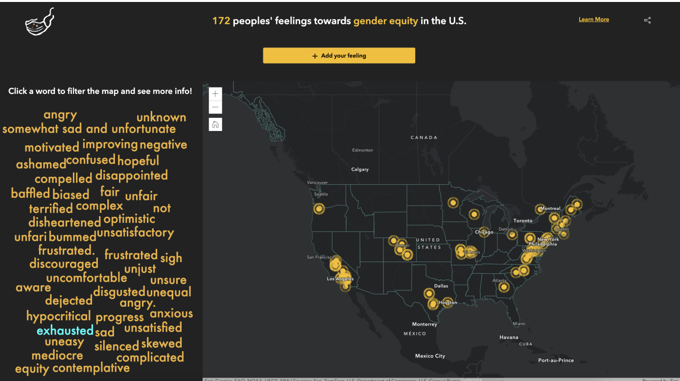
Apps and Data
Another crucial goal was to develop a range of custom apps that demonstrated the capabilities of Esri's APIs and SDKs, with a strong emphasis on accessibility. We aimed to ensure that the apps we created were easily accessible to all users, regardless of their abilities or technological preferences.
By leveraging Esri's powerful APIs and SDKs, we were able to build innovative and user-friendly applications that showcased the potential of geospatial technology. These apps were designed to provide intuitive interfaces, seamless interactions, and inclusive features, enabling a wide audience to engage with the data and insights presented.
Through our commitment to accessibility, we strived to break down barriers and make geospatial technology more accessible and beneficial to users of all backgrounds and abilities.


Accessible Information with Action
Recognizing the importance of information during election time, our focus extended beyond merely providing voting-related information. We aimed to inspire action among users by offering clear next steps, ensuring that they did not encounter dead ends but instead found guidance on how to actively engage in the democratic process.
By providing comprehensive and actionable information, we sought to empower users with the knowledge and resources necessary to participate effectively. We aimed to bridge the gap between information and action, motivating individuals to take the necessary steps to make their voices heard and contribute to the electoral process.
Our goal was to foster a sense of empowerment and agency among users, ensuring that they not only gained knowledge but also understood how to channel it into meaningful actions. By offering clear next steps, we aimed to transform passive information consumption into active civic engagement.


Outcome
Product In the News
The team was recognized in several different publications in the GIS and Political field.
READ-> Making People Vote and How!
How a women-led advocacy group used the power of maps to encourage people to vote by making the US Presidential elections personal, and by telling focused...
READ -> How to Spot Misleading Election Maps
Election results often produce confusing cartography. Here’s how leading cartographers and data journalists approach the challenge of making (and reading) political graphics...
READ -> Black Girls M.A.P.P. Launches a GIS-Powered Voter Information Site - GIS Lounge
Black Girls M.A.P.P., an employee resource group at Esri, has launched a GIS-powered site called People for the People to provide more voters with the information they need to participate in the upcoming November 3rd election in the United States...
READ -> Women-led advocacy group uses power of maps to encourage people to vote
This interactive map from People for the People, a volunteer advocacy group that arose from the Black Girls M.A.P.P. employee resource group at Esri, highlights states that have had elections determined by a close number of votes...
READ -> Check out Esri on Inc.com!
Esri's ArcGIS software has long been used to track natural and human-made disasters. Esri employees also were actively engaged in supporting voters during the 2020 election. An employee resource group at Esri called Black Girls M.A.P.P. spun off a volunteer advocacy initiative that saw 150 staffers donate 1,200 hours toward building data-driven narratives about policies affecting communities under-represented in the political process...